Mansehra at an elevation of 3574 feet ASL, is 24 kms from Abbotabad.It was founded by Sardar Maha Singh a Sikh administrator in the reign of Maharaja Ranjit Singh.The site of the city had its relation with Maurya dynasty. The city is consisted on both many attractive old and modern buildings. The route to Mansehra -Naran is full of scenery along the mountain peaks up to Bisian and along the river Kunhar and high peaks thereafter. Distant and just on the road views while travelling to Kaghan Valley upto Babusar Top are very entertaining besides other nearby tourists spots
Map of Kaghan Valley

 |
| Ashoka Stone Mansehra Views |
 |
| Khali Ghat |
 |
| Karakorum Hotel |
 |
| Mansehra Road
Batrasi at an elevation of 3648 feet ASL, is 15 kms from Mansehra.There is a thick pine forest on the plain and slopes of the hills and flowers of different kinds/fragrance are grown everywhere.
Views of Batrasi       
Balakot 3208 feet ASL is 26 kms from Batrasi. Almost all the tourists goods are available at cheap prices.The city has very important historical reference to a sacred war fought between the Sikhs and the Muslim mujaheddin including Syed Ahmad Shaheed and Shah Ismaeel Shaheed in 1831 AD.The mausoleum of these great fighters and other martyres are present in and around the city.The city inhabited at both banks of the river Kunhar.
Views of Balakot         
Kiwai is located at left bank of river Kunhar at an elevation of 5,115 feet ASL and 24 kms from Balakot. A waterfall on this spot is very charming. Besides it is a bifurcation point of Shogran road from Naran road. The waterfall has beautiful scenes in surrounding and a trout fish hatchery at a nearby Shinu village is also entertaining.
Views of Kiwai    
Paras at an elevation point of 4,302 feet ASL is 7 kms ahead of Kiwai. A rough track of 15 kms ascends at the right bank of the river Kunhar for Sharan valley at 7,872 feet ASL.The track is very steep and difficult and trekking is not advisable from this side. Access to the peak Mussa Ka Mussala 13,372 feet ASL and Siran valley through trekking is also possible from Paras.Adventure should be conducted through local guides to avoid the black bear in the thick forest and complete isolation.The other surrounding site include Shinu and Malkandi.
Views of Paras  Jareed at an elevation point of 4,9 44 feet ASL is 12 kms ahead of Paras.There is a state run Wood working Center some handicraft shops sell traditional style carved furniture. Hand made shawls and other prvisions are also available. The other surrounding villages include Manoor and Bela Manoor. 
Mahandri at an elevation point of 5090 feet ASL is 3 kms ahead Jared, a Hindi word which means meeting place of two rivers. A stream flows from Manoor Gali falls into river Kunhar at this place.Trekking to Kach, Biarhi and Manoor Galis starts from here. Trekking is a little bit hard but passes through beautiful meadows and forests and finally leads to Ansoo and Saif-ul Maluk lakes.
Views of Mahandri    
Khanian that is 11 kms ahead of Mahandri is a small but attractive village at the right bank of the river Kunhar.From here a jeep track climbes to Danna, a pieceful meadows at about 10,000 feet ASL.This jeep trck was destryed by 2005 AD earthquake and now it can be travelled on foot in 3 hours. Hikers can plan a night stay because this place is free from bandits but food stuff must be carried. Further access to another beautiful place Kamal Ban Forest at 6,500 ASL can be made by climbing to the south of Khanian. It is a thick and beautiful forest of centries old fir trees with highest dia and length in the area but trekking must be careful because there may be tigers and bears at some alone areas.
Views of Khanian

Kaghan at an elevation point of 6767 feet ASL is 6 kms ahead Khanian It is the village that gave name to the valley.There are villages like Lambi Patti,Paludaran,Andhera Bela,Kinari Rajwal,Rawalkot,Agla Gran,Lari I,II,III,and Khanian on either side of the Kunhar. A track to Malkandi Forest 8 kms to the west is full of tigers,leopards and bears etc. Whereas Shingri peak is just above the east of Kaghan at 12,700 feet ASL presents a superb view of Kaghan.
Views of Kaghan      
Naran is located 22 kms ahead Kaghan at the left bank of the river Kunhar.It is existed at an elevation point of 8,036 feet AsL.Naran is the base camp to many beautiful places which can be visited by either of jeep,car,trekking or hiking.Some impoetant places are exlained as follow.
Views of Naran
   
Jati Lake (Payala Lake) is located at 5 kms from Naran near Ghamla. It is a cup shape lake and referred as very deep lake.
Views of Jati Lake
  
Lake Saif-ul-Maluk at an elevation point of feet 10,550 ASL is 9 kms ahead of Naran.Lake is associated to famous prodigy" Saif-ul-Maluk" written by sufi poet Mian Muhammad Bakhs. According to the tale the prince of Persia fell in love with a fairy princess Badr-i-Jamal who used to come at this lake.Thus the lake was named after the Prince. the shades of the Malka Parbat reflects in the lake from the hieght of 5,500 feet above this lake.
Views Lake Saif-ul-Maluk
      
Ansoo Lake was discovered by pilots of Pakistan Air Force in 1994 AD. It is existed at an elevation point of 13,553 feet ASL. It is 11 kms ahead of Lake Saif-ul-Maluk which include 7 kms trekking and 4 kms hiking through Kuchh Gali at 13,000 feet ASL. It is also accessible from Mahandari through most beautiful Manoor Gali from where it is about 8 kms trekking but it is very difficult to trek from here.
Views of Ansoo Lake        
Batakundi is 15 kms from Naran and located at an elevation point of 8854 feet ASL.There are sights of worth seeing around this place besides a beautiful waterfall just on the road. Mountainers use to make this place a base camp of many beautiful valleys like Dadar,Siran and Chitta etc. all more than 10,000 feet ASL. Attempts are also made from these places to climb Malika Parbat whose South Summit is 17,356 feet ASL and North Summit is 17,134 feet ASL.
Views of Batakundi
     
Malika Parbat 1964 AD
 
Lalzar at an elevation point of 10550 feet ASL is 6 kms jeep route from Batakundi.The pleatue is filled with fragranc of the flowers of different colours.Small water channels are flowing everywhere.There is a trekking route of 6 hours to Lake Saif-ul-Maluk through Huns Gali located at 13,100 feet ASL. A pleasant view of Malika Parbat at 17,356 feet ASL can be taken from this lush green lawn.
Views of Lalazar  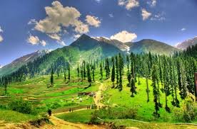    
Jalkhad is 25 kms from Batakudi and located at elevation of 10,500 feet ASL is 11 kms ahead Burawai which is at 9,656 feet ASL. Trekking from Jalkhad is possible to many lakes including Lulu Sar,Dodipat Sar,Sat Sri Mala,Sangar,Babusar,Nuri,Ratti Gali, Huns-Jor,Sambak,Saral and Gattian etc.
Views of Jalkhad  
Besal is 7 kms from Jalkhad on the Road to Babusar Top. Bans Gali, a trekking route at an elevation of 15,220 feet ASL,connects Besal to Batakundi.The road from north to Jalkhad ascends sharply towards Besal but it is less green than other places in the surrounding areas.
Views of Besal
 
Nuri Nar Pass is accessible through a jeep route bifurcated at Jalkhad from Naran Chilas Road.This 5 kms distance is difficult one and may be travelled in 2 hours through a pass at 12,102 feet ASL. This track leads to Sharda and Kel in Neelam Valley Azad Jammu & Kashmir. Ratti Gali Lake is located at 16,573 feet ASL and it can be accessed through trekking of nearly 6 hours. Another beautiful trekking can be made to Gattian Lake that is near nuri top where road descends into Kashmir.

Gitti Das is located at 17 kms from Besal. Famous Dharam Sar Lake is only 10 minutes walk from main track whereas Sambak Sar Lake is located between Gitti Das and Babusar Top.
Views of Sambak Sar and Dharam Sar Lakes
   
Lalusar Lake at an elevation point 11,345 feet ASL is 4 kms from Besal. Kunhar river originates from this Lake. Dodipat Sar Lake is located at 12,800 feet ASL and further trekking of 7 hours from Lulu Sar Lake ,Sat Sri Mala Lake a group of 7 lakes among which Surkhail Lake is the at the top being 14,000 feet ASL. Saral Lake located at 11,800 feet ASL is trekking of 4 hours from Dudipat Sar lake .This lake is located near to Neelam Valley Azad Kahsmir with a distant view of Nanga Parbat.
Views of Lalusar Lake
   
Dudipat Sar Lake 12,800 feet ASL is 24 kms from Jalkhad and 17 kms from Besal. It is located at 7 hours trekking from Lulu Sar Lake.Dudi means white which was derived from its white colour reflection of surrounding snow capped peaks in the deep water of the lake. the travelling is possible through hiring of either local guides with ponnies however it is better to bring food from base camp.
Views of Dudipat Sar Lake
        
Babusar Top is the highest and last point of the Kaghan Valley that is located at 13,690 feet ASL.It is 185 kms from Mansehra,148 kms from Balakot and 66 kms from Naran.This Top connects Kaghan Valley to Karakorum Highways at Chilas which then leads to China through Khunjrab Top Gilgit. The access to Babusar Pass from Naran is open from mid of July to September but it is restricted in winter and monsoon.This Pass was originally a pony track built by the British in 1892 to access to Gilgit. Before this area was connected through Bruzil passy from Srinagar. The Babusar Pass remained the main route to connect Silk Route uptill construction of KKH in 1974. The snow capped peaks of Chilas are 50 kms from the TOP.The lake Sambak Sar is located between Babusar Top and Gitti Das.
Views from Babusar Top
       |
Really I enjoy your site with effective and useful information. It is included very nice post with a lot of our resources.thanks for share. i enjoy this post,
ReplyDeletehttps://royaltaxi.pk/
Cheap Car Rentals in Islamabad